Brief description of fishery:
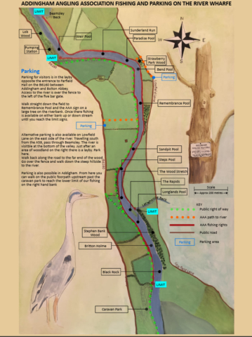
The club controls two section of the River Wharfe, the main stretch runs from upstream of the pumping station on Bolton Road downstream to Olicana Caravan Park. Much of this water is double bank, please check the map for full details.There is also a members only stretch on the opposite bank to Low Mill.
Parking for visitors is in the layby opposite the entrance to Farfield Hall on the B6160 between Addingham and Bolton Abbey.
Google maps link – https://maps.app.goo.gl/MA6ZZNzdcZqaRvxk6
Please don’t leave your Day Ticket in your windscreen as the Baillif might need to see it. Instead, you should leave a piece of paper/card with either “A” or “AAA” on it.
Access to the river is over the fence to the left of the five bar gate.
Walk straight down the field to Remembrance Pool and the AAA sign in a large tree on the riverbank. Once there fishing is available on either bank, up or down stream until you reach the limit signs. There is livestock on the fields on either bank so please keep to the riverside footpaths.
Alternative parking is also available on Lowfield Lane. This is the lane on the east side of the river and is very narrow. Travelling south from the A59, pass through Beamsley. The river is visible at the bottom of the valley. Just after an area of woodland on the right there is a large lay by.
Google maps link – https://maps.app.goo.gl/pJx7thiaX4bajnvBA
Walk back along the road to the end of the wood.
Hop over the fence and walk down the steep hillside to the river.
Parking is also possible in Addingham on Bark Lane. From here you can walk on the public footpath upstream past the weir and caravan park to reach the lower limit of our fishing on the right hand bank.
Google maps link – https://maps.app.goo.gl/45ctjaFezuzfQG9H9
Species
- Brown Trout
- Grayling


